


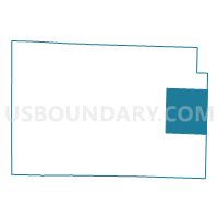
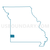
MCDONALD Voting District, Jasper County, Missouri
About
Outline

Summary
| Unique Area Identifier | 608766 |
| Name | MCDONALD Voting District |
| County | Jasper County |
| State | Missouri |
| Area (square miles) | 45.47 |
| Land Area (square miles) | 45.36 |
| Water Area (square miles) | 0.11 |
| % of Land Area | 99.76 |
| % of Water Area | 0.24 |
| Latitude of the Internal Point | 37.20599950 |
| Longtitude of the Internal Point | -94.11819100 |
Maps

Graphs
Select a template below for downloading or customizing gragh for MCDONALD Voting District, Jasper County, Missouri


Neighbors
Neighoring Voting District (by Name) Neighboring Voting District on the Map
- LINCOLN / SHERIDAN Voting District, Jasper County, MO
- NORTH MADISON Voting District, Jasper County, MO
- Red Oak Voting District, Lawrence County, MO
- REEDS / LA RUSSELL Voting District, Jasper County, MO
- SOUTH MADISON Voting District, Jasper County, MO
- Vineyard Voting District, Lawrence County, MO
Top 10 Neighboring County Subdivision (by Population) Neighboring County Subdivision on the Map
- Sarcoxie township, Jasper County, MO (3,043)
- Madison township, Jasper County, MO (2,502)
- Union township, Jasper County, MO (2,296)
- Vineyard township, Lawrence County, MO (1,048)
- McDonald township, Jasper County, MO (810)
- Red Oak township, Lawrence County, MO (410)
- Lincoln township, Jasper County, MO (296)
Top 10 Neighboring Place (by Population) Neighboring Place on the Map
Top 10 Neighboring Elementary School District (by Population) Neighboring Elementary School District on the Map
Top 10 Neighboring Unified School District (by Population) Neighboring Unified School District on the Map
- Sarcoxie R-II School District, MO (4,107)
- Miller R-II School District, MO (4,104)
- Jasper County R-V School District, MO (2,971)
- Golden City School District, MO (1,688)
Top 10 Neighboring State Legislative District Lower Chamber (by Population) Neighboring State Legislative District Lower Chamber on the Map
Top 10 Neighboring State Legislative District Upper Chamber (by Population) Neighboring State Legislative District Upper Chamber on the Map
Top 10 Neighboring 111th Congressional District (by Population) Neighboring 111th Congressional District on the Map
Top 10 Neighboring Census Tract (by Population) Neighboring Census Tract on the Map
- Census Tract 4703, Lawrence County, MO (5,445)
- Census Tract 4701, Lawrence County, MO (4,162)
- Census Tract 121, Jasper County, MO (3,791)
Top 10 Neighboring 5-Digit ZIP Code Tabulation Area (by Population) Neighboring 5-Digit ZIP Code Tabulation Area on the Map
- 64836, MO (23,940)
- 64862, MO (3,337)
- 64748, MO (1,493)
- 64859, MO (1,358)
- 64848, MO (744)
- 64833, MO (125)